Losing Faith in big dams? 5 of India’s biggest offer a clue
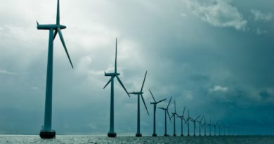
From fewer than 300 in 1947, the number of large dams surged to over 4000 by the year 2000, with more than half the dams being constructed between 1971 and 1989. Currently, the total number of large dams as per the National Register of Large Dams, is 5254 (this figure does not take into account the 447 large dams currently under construction), with India ranking third after USA and China when it comes to dam building. Over 96% of the dams built in the country are for the purpose of irrigation. But these ‘temples of modern India’ as the first Prime Minister called them, come at high cost, sometimes deemed high enough to dismantle the dam itself, as being done in many places in North America. These costs are broadly- rehabilitation, real cost, real delivery versus promises, environment impact, and Climate change impact on dam’s real usefulness or life cycle.
‘Aviral Dhara’, or uninterrupted flow, is a new slogan we see as wall graffiti, that last refuge of the completely frustrated protestor, in many places in Uttrakhand or Madhya Pradesh, home to two of the most recent and largest dams, the Tehri Dam and the Sardar Sarovar Dam.
In India, where we are used to literally and figuratively pushing all our resources way beyond rated capacity, be it roads, bridges, railways, airports and even space exploration, our biggest dams have survived deep questioning. Lets find out more by considering India’s top 5 dams.
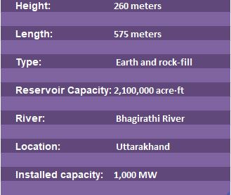
Tehri Dam, Uttrakhand
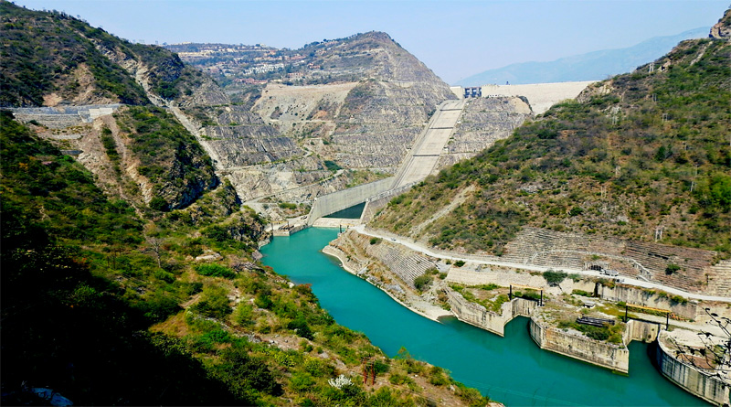
Current Status
Tehri Dam is located on the Bhagirathi River in Uttarakhand. The dam is currently the highest dam in India and the eighth tallest in the world, with a height of 261m. The dam currently has an installed capacity of 1000MW. It supplies water for irrigational purposes to approximately 667,185 acres of farmlands. Furthermore, it supplies an approximate 270million gallons of drinking water per day to the states of Uttrakhand, Uttar Pradesh and Delhi.
Issues
- 32 years on and still doesn’t have the promised capacity: Out of the promised 2400MW power generation capacity, the plant currently only has a capacity of 1000MW mainly due to the stalled construction as a result of the Tehri Andolan.
- Poor rehabilitation: The construction of the Tehri Dam affected over 100,000 people i.e. approximately 20,000 families. These families have still unhappy with the relocation and are missing basic amenities and accessibility to schools, hospitals, etc. all of which was promised to them by the government. Promised compensation of RS 1.5 lacs each, a laughable amount today, has seemingly not reached many too.
- Seismic risk: Besides numerous reports submitted to the government concerning Tehri Dam’s location, the government has repeatedly ignored the fact that the dam is built in a highly seismic region. Claimed to be built to withstand earthquakes up to 8.5 on the Richter Scale, experts believe that the region could be affected by earthquakes of higher magnitudes, which could cause a disaster
- Landslide prone region: Landslides are a common phenomenon in the region. This poses a risk of debris falling into the reservoir and causing a sudden increase in water levels.
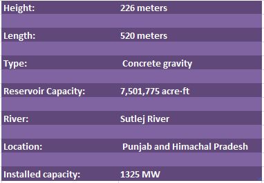
Bhakra Nangal Dam, Himachal Pradesh
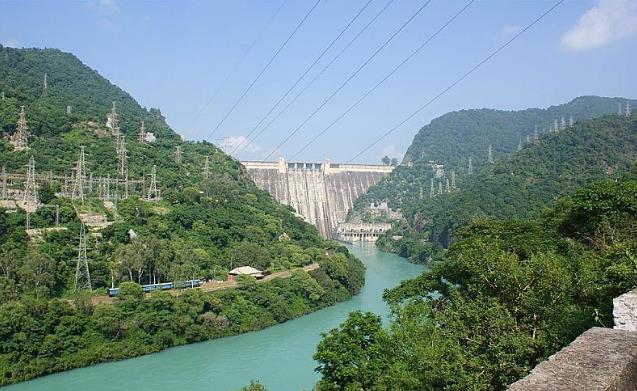
Current Status
The Bhakra Nangal Dam is a gravity dam built across the river Sutlej. The Bhakra Nangal dam was the largest dam in India (Sardar sarovar is now the largest in the country) and is the second tallest dam in Asia after the Tehri Dam, at 225m. Its reservoir known as Gobind Sagar is the second largest in India and has a capacity to hold 9.34 billion cubic metres. The dam was built essentially for irrigational purposes and currently provides water for 10 million acres of farmlands in the states of Punjab, Himachal Pradesh, Haryana and Rajasthan (this figure is claimed by the officials). It has an installed capacity of 1325MW and distributes power to Punjab, Haryana, Rajasthan, Gujarat and Himachal Pradesh.
Issues
- No clue of actual figures: The actual figures of the irrigational use of water from the dam is not available and authorities have refused to divulge the information as well.
- Water pollution: Besides the loss of forestation and wildlife due to the large catchment area, the construction of the dam has led to an increase in water pollution as a result of excessive use of chemical fertilisers and pesticides by farmers in the region.
- Rehabilitation numbers game: More than 50 years after its construction the people are still fighting for rehabilitation. The Bhakra Nangal Dam caused the submergence of 10,000 acres of agricultural land and 20,000 acres of forest land and displaced a total of 371 villages. More than 3600 families were displaced but the official record only shows a total of 11,000 people.
- Empty promises: The displaced families were promised land in Haryana but only 800 families out the 3600 have been given ownership of the lands, causing 740 families to return back to Himachal and the rest to rehabilitate in the forests.
- Decreasing capacity: The silt deposit in the dam’s reservoir has caused the capacity of the dam to reduce by 15%. Massive deforestation, cultivation and construction along the course of Sutlej as well as along its tributaries and rivulets have added to the problem of excess silt, especially during rains.
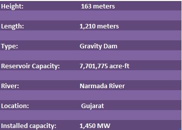
Sardar Sarovar Dam, Gujarat
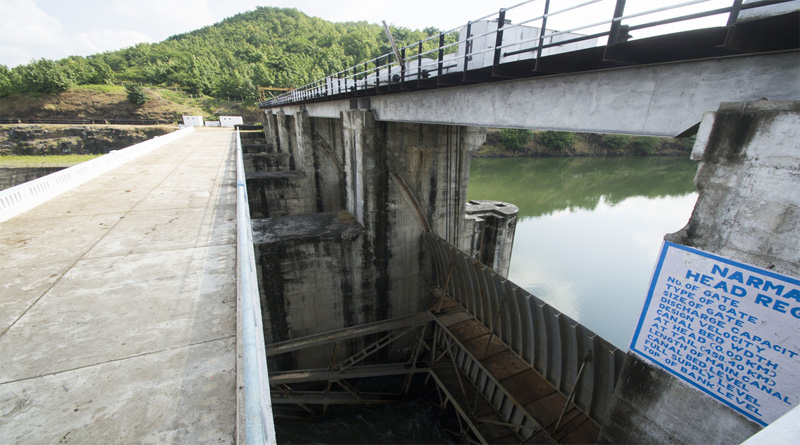
Current Status
The Sardar Sarovar Dam inaugurated last year by Prime Minister Modi on the occasion of his 67th birthday, is India’s largest dam and the second largest dam in the world with a reservoir capacity of 9.49 billion cubic metres. The dam is estimated to irrigate over 4 million acres of farmland and has a total installed capacity of 1450 MW out which 57% of power is to be supplied to Maharashtra, 27% to Madhya Pradesh and 16% to Gujarat.
Issues
- Incomplete project: The project is still incomplete, over 30,000 km of canals are yet to be constructed.
- No assessments being carried out: The Garudeshar Dam of the Sardar Sarovar Project is still under construction without any social or environmental impact assessment.
- Where are the assessments: There are no credible sources for assessing the costs and impact of the project.
- Pocketing water for the wealthy: Even though the Gujarat government claims the project to be necessary for water scarce areas like Kutch and north Gujarat, all the incomplete canals are situated in these very areas and while the economically and politically powerful regions of the state enjoy the benefits of the 18,000 completed canals leading one to wonder why were these canals not completed for the scarce regions. Overrated water flows are becoming a real issue, going by the past three years flow data.
- Rehabilitation: 80% of the rehabilitation is still incomplete, more so even the highest judiciary of the country cannot account for the rehabilitation of the displaced population.
- Lack of evidence of water release: The 150km stretch of the Narmada downstream from the dam is now dry most of the year and the claim of 600 cusecs (cubic feet per second) being released not immediately downstream but several kilometers from the dam is not supported by any proper evidence.
- Was such a large dam necessary: The Sardar Sarovar reservoir can not be filled, and even the extent to which it was filled was possible only by stopping all power generation at the River Bed Power House for almost two monsoon months, and by reducing power generation at the upstream Indira Sagar and Omkareshwar dams by over 95% and depleting the meagre water storage. This begs the question. Was the data and assumptions correct?
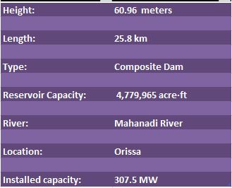
Hirakud Dam, Odisha
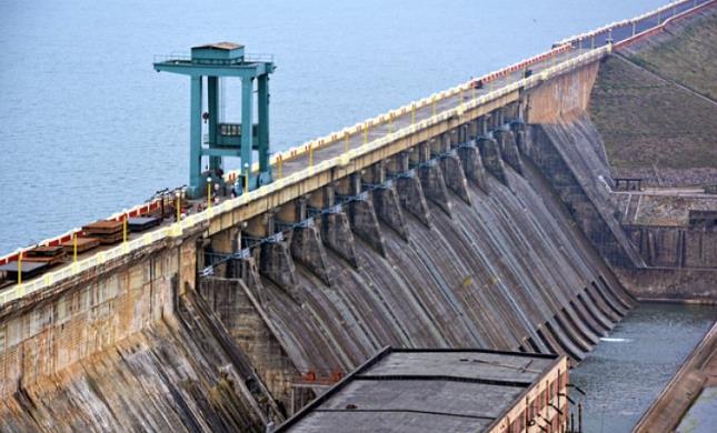
Current Status
Hirakund Dam is 15km from Sambalpur, Orrisa and is built across the Mahanadi River. It is the longest manmade dam in the world, spread across a length of 26km. It is estimated to irrigate 652,407 acres of land (Rabi and Kharif crops) and has an installed capacity of 307.5 MW. The dam’s main objective is to control the flooding in the Mahanadi delta, itself now becoming a bone of contention with neighbouring state Chhattisgarh.
Issues
- Failed flood control: The dam’s original design, though aimed at flood control, has failed to factor in real flood control measures. The reservoir does not have a specific ‘flood cushioning limit’ causing man-made floods due to the release of huge quantities of water from the dam. The authorities keep the water level almost than 15ft higher than its limit and “find it difficult” to release the water instantly when there is heavy rainfall upstream, this caused the floods downstream in 2011 and 2014.
- Rehabilitation game: The construction of the dam has submerged more than 360 villages covering more than 123,000 acres of land and has displaced 26,561 families. The government had promised all basic amenities to those displaced, including agricultural lands with irrigation facilities, education and health services in the resettled areas. They were also to be employed to compensate for what they lost out on, but these promises remain unfulfilled, six decades later. In 2010, the Economic and Political Weekly reported that, “In the process of rehabilitation, the government resettled 2,243 families in 18 different rehabilitation camps, which is only 8.46% of the total displaced people.” In 2014, out of the 26,561 displaced families approximately 10,000 families had still not allegedly received compensation.
- No allotment of land: Again, a case of tardy implementation and an article in itself
- Water shortage: Tap water connections haven’t been provided by the government in any of the resettlement colonies and the hand pumps installed are dysfunctional, making the people dependent on water tankers.
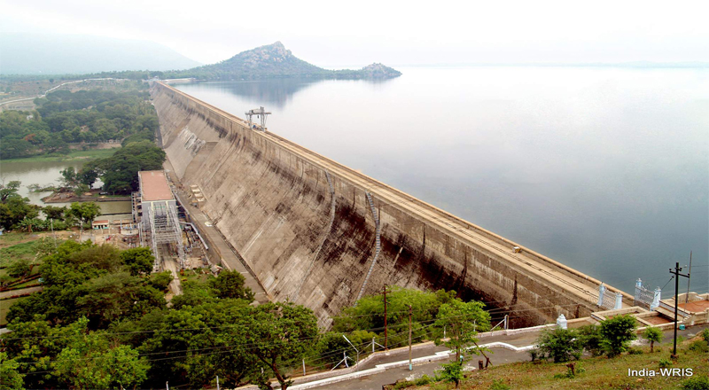
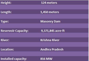
Nagarjuna Sagar Dam, Andhra Pradesh
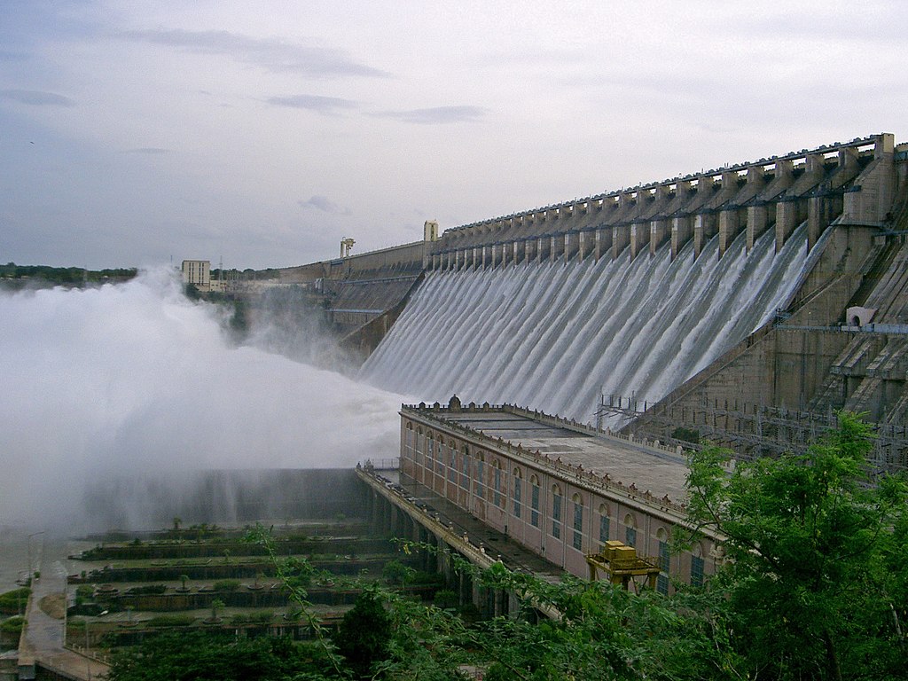
Current Status
Nagarjuna Sagar Dam is the tallest masonry dam in the world, it stands at a height of 124m. It is located 150km from Hyderabad and is situated on the Krishna River. The main objective of the dam is irrigation and it provides irrigation to four districts, namely Nalgonda, Guntur, Khammam and Prakasam, in total it claims to irrigate 1 million acres of land. It has an installed capacity of 816MW.
Issues
- Repeated Clashes between states: Andhra Pradesh and Telangana are constantly bickering due to the lack of water available in the reservoir for irrigation.
- Low maintenance of the dam: The dam has not revamped its systems since its completion in 1969 and the government has not acted upon upgrading the dam’s systems even though it acknowledges the issue.
![]()