El Nino Shadow Over Monsoons 2023
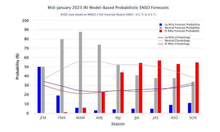
Climate Trends reports that according to NOAA, a transition from La Niña to ENSO-neutral is anticipated during the February-April 2023 season. What is concerning is the period thereafter wherein climate models are predicting a dominating chance of El Niño by the window of May-July 2023. The evolving phase of El Niño coincides with summer Monsoon that spans from June- September.
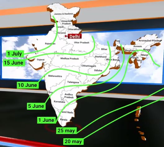
According to scientists and meteorologists, this is not good news for the upcoming Monsoon season, which in the past has led to some severe droughts during the El Niño years. The four-month long Southwest Monsoon contributes close to 75% per cent to the annual rainfall in India and irrigates over half of India’s agricultural land.
La Nina is all set to bid adieu, with the anomalies of cool temperatures in the Pacific waters are likely to dissolve. According to the latest forecast by NOAA, a transition from La Niña to ENSO-neutral will occur mostly during the February-April 2023 season. This is the first triple dip La Nina of the 21st century, which is also likely to be the longest on record. The simplistic view has been that whole El Nino is bad for South Asia, with the proven disruption that it will lead to for the monsoons, La Nina has usually turned out to be benign with those years bringing better monsoon rains in fact.
The occurrence of three consecutive La Niña in the Northern Hemisphere is a relatively rare phenomena and is known as ‘triple dip’ La Niña. A La Niña occurs when the temperature of the sea is cooler than average in the Eastern Pacific, resulting in less evaporation, weaker storms and less moisture in the atmosphere. This has also been blamed for more forest fires, drier weather and agricultural losses in the US for instance.
According to statistics, three La Niña events in a row has happened only twice since 1950.These La Niña instances were observed during 1973-1976 and 1998-2001. According to NOAA, the longest La Niña was 37 months, from the spring of 1973 through the spring of 1976. This was followed by 1998-2001, which stayed for over 24 months.
By February-April 2023, most models indicate the return of ENSO-neutral, with a probability of 82%.
El Nino Returns
Climate models are predicting potential return to El Niño by May-July, which coincides with summer Monsoon that spans from June- September.
Source Credit: NOAA
“During a La Niña, the tropical Pacific soaks up heat like a sponge and builds up the warm water volume. This is the warm water that spills across from the western Pacific to the eastern Pacific during an El Niño. Three consecutive years of La Niña means that the warm water volume is fully loaded and it is likely that the system is ready to give birth to an El Niño. Will it be a strong El Niño like the one during 2015-16? We may get some indications in spring itself,” said Raghu Murtugudde, Visiting Professor, Earth System Scientist at IITB and Emeritus Professor at University of Maryland.
Relation between El Nino and Southwest Monsoon
El Niño is invariably linked with poor Monsoon performance and has been considered as a threat. According to statistics, about 60% of the time there will be a probability of drought in the country during an El Niño year. Chances of below-normal rain will be 30%, while the
prospect of normal rain remains very rare at 10%.
“As for the monsoon itself, if an El Niño state does emerge by summer, then we are more than likely to see a deficit monsoon. A transition from a La Niña winter (which we are in now) to a summer El Niño state tends to produce the largest deficit in the monsoon – of the order
of 15%. This implies that the pre-monsoon and monsoon circulations tend to be weaker,” added Dr Murtugudde.
However, a strong El Nino is no guarantor of a poor monsoon. For instance, even the strongest El Niño has given normal Monsoon rains of 102% in 1997, while weak El Niño conditions resulted in severe drought in 2004 to the tune of 86%.
If we look back at the statistics from the year 2000 till 2019 there have been four instances of drought years. In 2002 and 2009 the countrywide deficiency was 19% and 22%, respectively, which were considered severe drought years. While in 2004 and 2015 the
deficiency stood at 14% each, which was again a drought. There has been only one instance in the last 25 years (1997) that the country saw surplus rain of 2% despite El Niño.
“El Nino forecast is available for the next 9 months. However, model accuracy for the lead times greater than 4 months is generally low at this time. Yet, the past record of El Nino indicated around this time, is a testimony of spoiled southwest monsoon. ENSO forecasts of
December 2013 and December 2017 were akin to December 2022. Both these years witnessed sub-par southwest monsoon rainfall leading to moderate drought in 2014 and near drought in 2018. Earlier, similar patterns in 2003 and 2008 also proved dreadful, hurting Indian monsoon 2004 & 2009, both drought years. The initial projections indicate ENSO building up sharply and El Nino getting augmented rapidly during monsoon. As of now, the principal indicator Nino 3.4 holds ground and negative anomalies still prevail,” said GP Sharma, President – Meteorology and Climate Change, Skymet Weather.
The Two Saviours
In an El Nino year, MJO and IOD can be the two saviours for Monsoon Under the gloomy scenario of El Nino, the oceanic parameters – MJO (Madden-Julian Oscillation) and IOD (Indian Ocean Dipole) are the two knights in shining armour for the Southwest Monsoon. Both the weather phenomena, if in a positive phase, are variably related with good Monsoon rains over the country and are known for negating the effect of El Niño up to large extent. However, it is unclear whether that is a robust relation. It is also unclear if an IOD will evolve this year.
MJO is a transient feature that visits the Indian Ocean at least once and maximum up to four times in the four-month long Monsoon season. Meanwhile, IOD which is also known as Indian Nino, is an irregular oscillation of SSTs (Sea Surface Temperatures) wherein the western Indian Ocean becomes relatively warmer and makes the eastern side colder. This also affects the strength of Monsoon over the Indian Subcontinent. A positive phase sees greater than average SST and more precipitation in the western Indian Ocean region, with a corresponding cooling of waters in the eastern Indian Ocean. The negative IOD brings the opposite conditions.
Two-way relation between Global warming and El Nino Recent research indicates that the frequency of extreme El Niño events increases linearly with the global mean temperature, and that the number of such events might double (one event every ten years) under 1.5°C of global warming. This pattern is projected to persist for a century after stabilization at 1.5°C, thereby challenging the limits to adaptation, and thus
indicates high risk even at the 1.5°C threshold. Changes to the frequency of extreme El Niño and La Niña events may also increase the frequency of droughts and floods in South Pacific islands During and following El Niño, the global mean surface temperature increases as the ocean transfers heat to the atmosphere. Warming of the waters, such as during El Niño, eliminates the cloud deck and leads to further sea surface warming through solar radiation.
“We do get a mini-global warming during an El Niño since the warm water spreading across the Tropical Pacific release massive amounts of heat to the atmosphere. Headlines are already blaring that an El Niño this year could push global warming to rise past the 1.5C level. Unfortunately, it is not clear if that temporary blip will produce anything dramatic beyond the extremes we are already experiencing. El Niño will of course bring its usual global perturbations to the cyclones, monsoon, wildfires, dust storms, and so on,” said Dr Murtugudde.
Several researchers have already raised an alarm citing an increase in frequency of extreme El Niño and La Niña events from about one every 20 years to one every 10 years by the end of the 21st century under aggressive greenhouse gas emission scenarios.
In a warming climate, rainfall extremes are projected to shift eastward along the equator in the Pacific Ocean during El Niño events and westward during extreme La Niña events. Less clear is the potential evolution of rainfall patterns in the mid-latitudes, but extremes may be
more pronounced if strong El Niños and La Niñas increase in frequency and amplitude